Curated OER
Geographic Landforms
Each slide is a simple notebook page with one landform in blue and its definition in red. There are 26 vocabulary terms in all, some you may want to use, and others easily hidden. It is recommended that you add photos or other graphic...
Curated OER
Geography Color: Island
In this coloring geography worksheet, learners identify the picture of an island. Students then color the island and write a definition for the geographical feature.
Curated OER
Volcanic Eruption!
Young scholars define the three types of volcanoes. They explain how the three volcano types are created and how they change in size and shape. Pupils explain the difference between plutonic and volcanic rocks. Students recognize or...
Curated OER
Lesson Plan on Volcanoes
Fourth graders are able to label a diagram of a volcano with a least 3 of the following parts: the magma chamber, vents, dome, and caldarea. They break up into groups of four and design their own volvanoes using paper and drawing...
Curated OER
How Will We Get There?
Learners discuss and make a T chart of how to travel in Hawaii and understand that it is a group of islands that you cannot drive to. In this Hawaii lesson plan, students also discuss the kinds of transportation we use on the main land.
Curated OER
VOYAGE OF THE DAWN TREADER
Students create and write context sentences leaving a blank for each vocabulary word. Exchange papers with a classmate to fill in the blanks or use vocabulary cards to show answers. Students research the Isle of Wight in books on Great...
Curated OER
How Islands Form
Students how islands form, rising water levels, growth of coral, and volcanoes. They complete Island Investigation worksheets after researching island formation on various Internet websites.
Curated OER
Island Project
A new island has been discovered and Students use their knowledge of map skills to create a map illustrating economic development and resources. They determine the laws of the island and support each law with appropriate core values.
Houghton Mifflin Harcourt
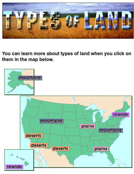
Harcourt: School Publishers: Types of Land
This clickable map of the United States defines different geographic features such as mountains, plains, islands, and deserts.
Encyclopedia of Earth
Encyclopedia of Earth: Nauru
The Encyclopedia of Earth provides an overview of Nauru, including its geography, natural resources, history, government, economy, and much more. Maps and images are also included, along with sources used to create the entry.
Encyclopedia of Earth
Encyclopedia of Earth: Montserrat
The Encyclopedia of Earth provides an overview of Monserrat, including its geography, natural resources, history, government, economy, and much more. Maps and images are also included, along with sources used to create the entry.


