Curated OER
Discovering American Symbols
Help youngsters get to know their states and capitals, explore their own country, and study American symbolism. They take a "trip" across America collecting symbols, images, and information about each state as they go (through text and...
Curated OER
Our States, My State
Here is a very nice lesson on the shape of the United States, and the shapes of the individual states for your young geographers. They utilize worksheets embedded in the plan to color in a variety of states and to become familiar with...
Curated OER
A Tough Nut to Crack
Sixth graders explore agriculture by examining world geography. In this pecan cultivation lesson plan, 6th graders identify the history of the famous nut and the impact it has on the U.S. economy, diet and human body. Students define...
Curated OER
Landmarks of the Underground Railroad
Students explore Civil Rights by reading several books in class. In this Underground Railroad lesson, students discuss The Story of Henry Box Brown and identify the location and functionality of the Underground Railroad. Students answer...
Curated OER
Maps Can Help Us
First graders explore the geography of Montana by analyzing geographic maps of the area. In this Native American reservation lesson, 1st graders discuss the similarities and differences between reservations in the state of Montana....
Curated OER
The Fifty States
Students become familiar with the states. They study capitols, mottos, nicknames, and other various details. They create group projects that be presented to the class.
Curated OER
50 States: New England States
Learners discover where certain states are located and what the look like. They look for their information on a web site. Each student is assigned a state which they must research then present to the entire class.
Curated OER
Roundtable
Fifth graders apply the Five Themes of Geography as they relate to the U.S., the world, and specific places in United States history. They recognize and label geographical locations on a map of the United States.
Curated OER
A Visit to Charm City
Students explore U.S. geography by participating in a role-playing activity. In this Baltimore history lesson, students discuss the geography of Baltimore city and complete a worksheet which discusses the "charm" Baltimore is known for....
Curated OER
State Geography-Kansas
Fourth graders locate and identify geographical features and on a Kansas map. In this Kansas geography lesson plan, 4th graders generate concepts to be added to a graphic organizer web map about Kansas. Students label or outline cities,...
Curated OER
States in the USA Quiz
In this online interactive geography quiz learning exercise, students respond to 50 identification questions about the states in the United States of America. Students have 4 minutes to complete the quiz.
Curated OER
Identifying Border States of the U.S.
In this identifying border states of the U.S. worksheet, 3rd graders visually identify then write the names of the states that border Canada and Mexico; page 1 is a lesson, page 2 is the worksheet.
Curated OER
Facts, Fictions and Perceptions of Regions
Students examine the different characteristics of the regions of the United States. They discuss places they have visited in the U.S., and in small groups conduct research on a selected region of the U.S. Each group labels a map of...
Curated OER
"Place the State" Game
Students participate in a computer game in which they locate and place the U.S. states on a blank outline map. In small groups, they take turns dragging and dropping the states in the proper location on a map.
Curated OER
America Will Be
Learners work together to research and create different types of maps of the United States to be used as part of a geography trivia game.Groups research North American annual rainfall, climate, mountain ranges major rivers and state...
Curated OER
The Eerie Canal
Students discover bodies of water in the United States by investigating the Eerie Canal. For this U.S. Geography lesson, students discuss Lake Eerie and the canal that was built in order to transport goods. Students research...
Houghton Mifflin Harcourt
Harcourt: School Publishers: Types of Land
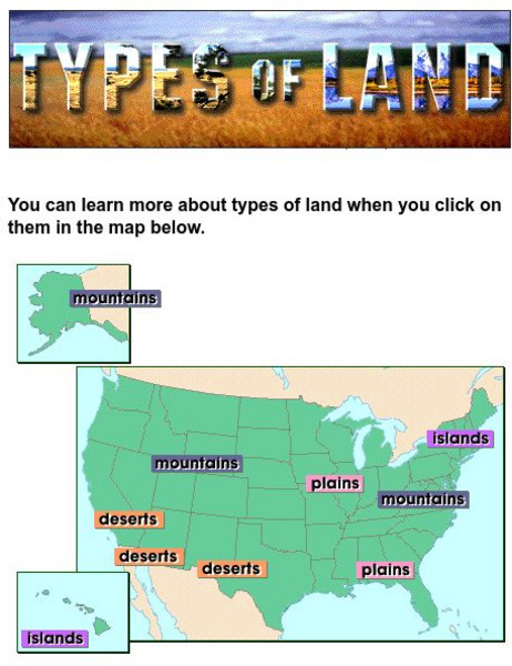
This clickable map of the United States defines different geographic features such as mountains, plains, islands, and deserts.
University of Texas at Austin
Perry Castaneda Library Map Collection: u.s. Maps
At this site find any type of map on the U.S. and any of its states here. Great site for teachers to print out maps to use in the classroom.
World Atlas
World Atlas: United States of America
A comprehensive guide to the United States of America including a variety of maps, statistics, facts, and information on history, geography, flags, symbols, travel, and much more.
ABCya
Ab Cya: u.s. States and Capitals: Penguin Hop
Don't slip on the ice! Up to four students at a time will drill states and capitals with this engaging game of penguins hopping on icebergs. Right and wrong answers are tallied and provided at the end of the game.
ABCya
Ab Cya: Geography Practice: Usa Puzzle Map
Assemble a puzzle of the United States to test your knowledge of its geography.


